|
||||
|
Sept. 22, 2001
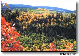
The colors are just beginning to change in Southwestern Colorado. The earliest color changes were reported in the higher elevations near Silverton. Between Cortez and Durango, the oak brush is turning, and there is deepening color in the oak and cottonwoods near Pagosa Springs. Fall golds and reds are nearing their peak along Highway 145 from Dolores to Telluride. The Cherry Creek area near Durango is also spectacular. The San Juan Mountains have three main species of deciduous trees that turn color in fall: aspen, cottonwood, and Gambel oak. Aspen grow from shared root systems at moderate to high elevations, so different clumps, or clones, of aspen trees will turn color together. Cottonwoods grow in riparian areas along rivers and creeks, and Gambel oak grows at lower to middle elevations. Leaves change color in response to the decreasing amount of daylight in autumn, but weather conditions, such as cooler temperatures, early frosts or drought, can affect the length and timing of the display. Elevation, latitude and slope aspect also determine when trees turn color. Hence, colors turn first farther north and at higher elevations. Autumn colors exist in leaves year-round but are hidden by chlorophyll, which produces the dominant green color. Trees use chlorophyll to convert sunlight into food. Changes in daylight, and to a lesser extent, temperature, slow food production in fall. As chlorophyll decreases, so does the green color, allowing hidden pigments to show through. The U.S. Forest Service offers a National Fall Color Hotline at 1-800-354-4595. Local information is available by calling: • Dolores Public Lands Center, 100 N. Sixth St., Dolores, 882-7296 • San Juan Public Lands Center, 15 Burnett Court, Durango, 247-4874 • Columbine Ranger District, 367 S. Pearl St., Bayfield, (970) 884-2512 • Pagosa Ranger District, Second & Pagosa St., Pagosa Springs, (970) 264-2268. For those who want to explore backcountry USFS or BLM roads in southwestern Colorado, the following routes are suggested. Check with USFS/BLM offices for maps and information on road conditions. Wet weather can cause temporary backcountry road closures. Remember that USFS and BLM roads are not paved or plowed for snow removal. Dolores Area: West Dolores/Meadows (Forest Rd. 535); Meadows (Forest Rd. 535); Black Mesa (Forest Rd. 611); Taylor Mesa (Forest Rd. 545); Stoner Mesa (Forest Rd. 686); Haycamp Mesa (Forest Rd. 556); Echo Basin (Forest Rd. 566); West Mancos (Forest Rd. 561). Durango Area: Lime Creek Road (Forest Rd. 591); Junction Creek Rd. (Forest Rd. 171); Missionary Ridge Rd. (Forest Rd. 682); Bolam Pass (Forest Rd. 578B); La Plata Canyon (Forest Rd. 571); Upper Hermosa (Forest Rd. 578). Silverton Area: Alpine Loop (State Hwy 110 and 149, County Roads 2 and 30); Ophir Pass (Forest Rds. 679 and 630); South Mineral (Forest Rd. 585); Stoney Pass (Roads 589, 737, 520). Bayfield Area: Middle Mountain (Forest Rd. 724); Beaver Meadows (Forest Rd. 135);Transfer Park (Forest Rd. 243). Pagosa Springs Area: First Fork of the Piedra (Forest Rd. 622); Plumtaw Loop (Forest Rd. 634);Quartz Meadows (Forest Rd. 684); Nipple Mountain (Forest Rd. 665); Piedra Rd. (Forest Rd. 631); Williams Reservoir (Forest Rd. 640); East Fork (Forest Rd. 667); Snow Springs (Forest Rd. 628). |
||||
|
Copyright © 2001 the Cortez
Journal. All rights reserved. |