|
||||
|
June 7, 2001
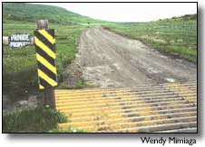
By Janelle Holden The nearest access road to a remote, newly-purchased subdivision in Dolores County was bladed this weekend without the consent of either the adjacent landowner or the Forest Service. The road, U.S. Forest Service Road 240, leads to Colorado Land and Ranches’ 3,048-acre property near Benchmark Lookout and crosses an archaeological site under consideration for listing on the National Register of Historic Places. "I just absolutely could not believe it," said Guyrene McAfee, the landowner of the property the road crosses. "It was just a really narrow little path. It was rutted some, yes, and there were a couple or three low areas. However, it definitely wasn’t flat," said McAfee. McAfee has been a vocal opponent of the 87-lot subdivision Colorado Land and Ranches is planning to develop south of critical big-game habitat on the adjacent San Juan National Forest. When Journal staff visited the area on Wednesday they found the road across McAfee’s property and part of the adjoining road on Forest Service property flattened and bladed. McAfee also said culverts were installed under the road without her permission. "I don’t know who it takes to stop them from taking their own sweet will and doing to anybody what they want to do. They have no regard for the law," said McAfee. The Forest Service currently owns the easement across McAfee’s property, which hides an archaeological site recommended for listing on the National Register of Historic Places. It also provides the best access to the proposed subdivision. Colorado Land and Ranches purchased the property from Blanding rancher Richard Perkins last month. The land company withdrew an application to improve the road this spring, citing the expense of a likely environmental assessment, but has recently applied for a permit to use the road during the dry season. Mike Znerold, the district ranger at the Dolores Public Lands Center, said that because of the archaeological site, the Colorado Historic Preservation Office had been asked to review the permit. The Colorado Historic Preservation Office’s recommendation was to approve the permit for one year as long as the developer used it only during the dry season without improving the road. According to Znerold, the permit is still under consideration. "They weren’t to touch the road. If they have, then it’s a problem," said Znerold who was unaware of the blading on Wednesday, but said he planned to investigate. Colorado Land and Ranches owner Bob Bourque could not be reached for comment on Wednesday. |
||||
|
Copyright © 2001 the Cortez Journal.
All rights reserved. |