|
||||
|
May 12, 2001
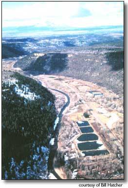
By Jim Mimiaga Journal Staff Writer The numerous gravel pits and ponds lining the upper Dolores River could increase flood dangers by altering the mountain stream’s natural course, a citizens’ group is claiming. Citizens for Accountability and Responsibility on the Dolores River formed last fall to research the cumulative impacts of having multiple gravel pits along a short section of the river. Within one mile there are eight ponds (mining pits are transformed into ponds), and within a five-mile section of the river there are 19 gravel-mine ponds, with more to come once planned mining expansions are complete. CFAR members, many of whom live in the midst of working or expired mining operations clustered north of Dolores, are trying to raise public awareness of the situation. "We understand the need for gravel resources," said Marilyn Boynton, a CFAR researcher. "We just don’t think this river valley is the best place to mine for it, considering the dangers of putting so many in that sensitive of an environment, and the scientific facts show this." The group, along with geology experts such as a Fort Lewis College professor, is concerned about the potential for so-called "pit-capture" in the event of flooding, which occurs every 10-20 years. With so many pits and ponds lined up in a row, the fear is that during a flood, they will fill, take out berms, and redirect the river into a new "captured" channel created by expired mines. Because of its steep gradient, narrow valley and heavy volume of snow melt, the Dolores River has flooded 11 times since 1912, according to state records. During the 1912 flood it ran at 10,000 cubic feet per second and flooded downtown Dolores. "It is a very powerful river and when it happens again, this pit capture would be disastrous," Boynton said. "For some property owners, like the Robinsons, Mr. (Bill) Ortiz and Jack Akin, it means their residences would be taken out by the new river course, their lives endangered and their property totally inundated." Rob Blair, a expert on fluvial geomorphology, and a recently retired geology professor at Fort Lewis, surveyed the region last month and confirmed the potential for increased flooding as a result of so many gravel ponds. "When gravel is removed from the flood plain, it changes the balance that the river has naturally achieved for maintaining its particular gradient," Blair explained. "Linked gravel pits along the flood plain tend to focus where floods will occur in the future in that they provide the pathways for the new channels during a high-discharge flood. This definitely has the potential to change the course of that river." Berms of tailings along mines can channel the river flow, or create dams, which increases erosion in those constricted areas. The result is that flood waters get "dumped in the area where the river spreads out again, increasing flood dangers for residents there, and possibly causing the river to become a more braided system," Blair said. The group is also researching cumulative effects of mines on aquifers and the potential for silt build-up in McPhee Reservoir from mine tailings during floods. Government regulators with the State Division of Mining and Geology have said that the law does not require them to consider the cumulative environmental impacts that multiple gravel operations may have on water quality and flooding. State statutes require that permit requests be considered case by case, based on their individual merits. "We think it is time they look at more," said Pat Kantor, CFAR president. The group is rallying around Carol Stepe and Jack Akin, the couple suing Montezuma County for granting a high-impact permit for a gravel mine at the Line Camp, despite widespread opposition. The commissioners granted the permit, arguing historical use of gravel mines in the area and the need to respect development rights on private property. Numerous examples exist of flooding rivers diverted by gravel pits into unexpected new courses that have been very costly to man, agreed geologist James B. Johnson, a Grand Junction geologist. "This behavior is so well-known, I am surprised it appears to have been ignored in the Dolores Valley," Johnson said. The citizens’ group has sent letters to Gov. Bill Owens and state representatives informing him of their concern, and are urging state geologists to look for alternative sources of gravel in less-populated areas of the county, such as Haycamp Mesa. But the problem is not just gravel pits, Blair cautioned. Scenic mountain rivers are also more and more stressed by vegetation depletion, increased residential development, and new roads, which — ironically — require ample gravel for construction. "Competing human development in general along rivers tends to constrict their flows and take up the flood plain they need," Blair said. "The concept of designing with nature in mind would help in reaching an equilibrium because there are limits that any river system can handle. "Establishing that line can be politically difficult, but not doing so can cause problems in the future." CFAR is pushing for a geological survey to be conducted on the Dolores River valley to quantify the dangers human impacts are causing. The group’s next meeting is May 14 at 6 p.m. in the Dolores Coffee House. |
||||
|
Copyright © 2001 the Cortez Journal.
All rights reserved. |